Archive
29 May Brown Family Homestead Easement
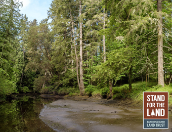
BILT Admin Brown Family Homestead This story begins in 1947 when Judy was 17 and her parents, Harlan and Ruth Reynolds, bought property along Sunrise drive with two other couples from their church. Judy and her husband Jack moved to the property in 1978 to live alongside her parents; in 1999 they donated a conservation easement to the Land Trust. The entire 3.2-acre property is encompassed by this protective easement, a voluntary legal agreement between the Land Trust and a landowner that allows the landowner to retain ownership, but preserves the conservation values of a property forever. “Judy and Jack Brown made the decision to put the land into a Land Trust conservation easement in order to protect the beauty and life it harbors”, says Leyla Welkin, Judy’s daughter, “and to honor the dream of Harlan Reynolds that the land should foster connectedness for his family.” Why this property? Part of the beauty that Judith and Jack sought to preserve is a backshore wetland that covers the east portion of the property. Backshore, or tidal wetlands, occur along shorelines and are influenced by the tide. Together with a neighboring easement, the Brown Conservation Easement ensures that despite changes to the surrounding parcels, this wetland and the species and processes it supports will be protected forever. In 2014, Judy placed the land into the Brown Family Homestead Trust in hopes that it will stay in the family for years to come. The ashes of Harlan, Ruth, their son Kenneth, and Judy’s husband Jack are all in the garden, and three grandchildren and one great grandchild have been born in the house. Leyla’s two sons currently live on the property with their wives and children, and all of her siblings regularly visit. She says, “We are all grateful for the way that the beauty...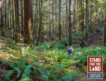
04 May Jablonko Preserve
BILT Admin Jablonko Preserve Stand for the Land began with the acquisition of a spectacular parcel adjacent to the Gazzam Lake Nature Preserve. In 2018, the Land Trust publicly announced the acquisition of 14.17 acres of the Peters Tree Farm adjacent to the Gazzam Lake Nature Preserve, in collaboration with a multi-generational family represented by Alison Peters Jablonko. The Land Trust has worked with sisters Olemara Peters and Allison Jablonko on their family’s land for more than 25 years. In fact, many of our projects involve legacy lands like this one—property that has been in a family for generations. The Jablonko Preserve consists of undeveloped forest land. It is a portion of holdings that the Peters/Jablonko families have owned since 1951 (originally 110 acres). To get to the Preserve, visitors will walk through the 49-acre Peters Tree Farm preserve, purchased in 2004 and part of the Gazzam Lake Nature Preserve. Why this property? Three key reasons. Natural Habitat – The Jablonko Preserve’s natural systems are stable and healthy, with multi-storied forests comprised primarily of 60-80 year-old Douglas-fir and western red cedar, as well as western hemlocks, red alder, big leaf maple and madrones. The understory is diverse, with sword fern, evergreen huckleberry, salal, oceanspray, and red elderberry. Forest forbs (non-woody flowering plants) such as vanilla leaf, foam flower, violets, and pathfinder are common along the trails. Nearly every shrub species here produces edible fruits or seeds, providing both food and cover for local wildlife including raccoons, Douglas squirrels, deer, hairy and pileated woodpeckers, and a variety of other critters and birds. Wildlife Networks – the Land Trust has a strategic focus on creating or further expanding connections between preserved lands. We purchased this particular 14-acre portion of the Jablonko/Peters Tree Farm property because it is contiguous to already protected lands and trail...
04 May Cougar Creek Preserve
BILT Admin Cougar Creek Preserve A new opportunity with very old roots. Looking for big reasons to support the Land Trust’s ambitious Stand for the Land movement? Look no further. The gorgeous 15-acre Cougar Creek preserve above Eagle Harbor was once owned by Captain William Renton and is now home to some of the largest and most magnificent western red cedar trees on the Island. A flowing stream and serene pond enhance the undisturbed forest habitat. Our trail cameras have snapped photos of families of deer and raccoons foraging, great blue herons wading, coyotes, opossums, and even a black bear! Red-legged frogs, Pacific chorus frogs and northwestern salamanders lay their eggs in the pond, and the frogs can be heard in full chorus on spring evenings. Pileated woodpeckers and barred owls are also frequently heard from the public access trail, which connects Blakely Avenue NE to Old Mill Road NE and passes by the pond. As described by a Land Trust volunteer familiar with the Preserve: “The parcel feels remote and even bigger than it is: big logs, dense undergrowth (native, not invasives!), and huge 5 and 6-foot diameter red cedar and western hemlock trees. On the property, I savored a true, natural Northwest forest, undisturbed for a long time. The property contains some of the largest trees on Bainbridge Island and an undisturbed garden of deer ferns. In the stream bottom area is an extensive grove of large western red cedar, and nestled in its heart is a big garden of solid deer ferns, something I haven’t seen elsewhere on the Island. Put all this together with the stream, pond, and wetlands that characterize the property, and you have a parcel that contains a lot of diversity and feels big and wild.” Why This Property? The Cougar Creek Preserve makes a...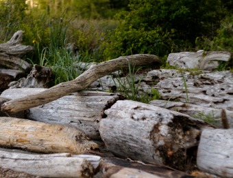
11 Apr Hawley Cove Park
BILT Admin Hawley Cove Park Almost two decades ago, the Land Trust identified the 11.7-acre Hall Family shoreline property as ideal for preserving and protecting. In 2001, the Land Trust and its volunteers helped to negotiate an option agreement with the Halls, and provided legal support in the negotiations, working in partnership with the City of Bainbridge Island’s Open Space Commission. The City purchased the property using levy funding, eventually transferring it to the BI Metro Park and Recreation District which owns and manages this park. The property contains upland forest, a large wetland, and 609 linear feet of saltwater shoreline on Eagle Harbor. It also has a 400 foot boardwalk and .25 mile walking trail from Wing Point Way to the shoreline on Eagle Harbor. About the Open Space Commission The City’s Open Space Commission was established in 2001 by City ordinance to recommend specific properties for preservation to the Bainbridge Island City Council. Funds to protect these open spaces, which included natural areas and farmlands, came from an $8 million levy approved by voters in 2001. The Open Space Commission's work ended in 2008 and resulted in hundreds of acres of public lands for parks and farms. Acres Protected 11.7 acres Conservation Features Coastal ecosystem Wetlands Scenic & open space values Habitat for migratory birds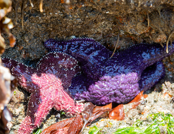
11 Apr Rockaway Beach Park
BILT Admin Rockaway Beach Park In 2002, Land Trust identified the Rockaway Beach shoreline property as a prospective conservation property. The Land Trust and its volunteers helped to negotiate an option agreement with the landowner, and provided legal support in the negotiations, working in partnership with the City of Bainbridge Island’s Open Space Commission. The City purchased the property using levy funding, eventually transferring it to the BI Metro Park and Recreation District which owns and manages this park. This beachfront park has sweeping views of Seattle and the Cascade mountains, and contains wetlands and saltwater shoreline near Blakely Harbor. Picnickers have access to a table and benches, while divers can use a stairway for scuba diving access to Blakely Harbor North Point and Blakely Rock. Low tides provide excellent marine life viewing. The City’s Open Space Commission was established in 2001 by City ordinance to recommend specific properties for preservation to the Bainbridge Island City Council. Funds to protect these open spaces, which included natural areas and farmlands, came from an $8 million levy approved by voters in 2001. The Open Space Commission’s work ended in May 2007 and resulted in over 800 acres of public lands for parks and farms. Acres Protected 1.3 acres Conservation Features Coastal ecosystem Tidepools and beach Scenic & open space values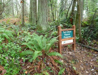
11 Apr Ted Olson Nature Preserve
BILT Admin Ted Olson Nature Preserve History The History of the Ted Olson Preserve starts in 1973 when Theodore Olson donated a large parcel of land to the Bainbridge Island Metro Park and Recreation District. He believed that it was important to conserve land on Bainbridge Island and was committed to preserving this 10-acre property. In the spirit of his vision, over thirty years later, a new initiative began to acquire an adjacent 5-acre parcel, which would extend the Ted Olson Preserve further east. What is truly special about this initiative is how it came to pass, since it was genuinely a project driven by the community. Inspired by Ted Olson’s vision, Islanders asked the City’s Open Space Commission to buy the 5-acre parcel. Local citizens, neighbors, and the City of Bainbridge Island with the support of the Park District’s Board of Commissioners worked together with the Bainbridge Island Land Trust, to fund the 5-acre Ted Olson addition through private donations and the City’s Open Space Bond Levy funds. The Land Trust placed a perpetual conservation easement on the 5-acre parcel. The property was then transferred to the Park District. This 15-acre preserve stands as a monument to the tremendous resolve and power of Islanders working together with the Land Trust, the Park District, and the City in influencing the development of our community’s natural and preserved areas. 2021 Expansion This exciting opportunity helped expand the current Ted Olson Nature Preserve – a beloved public space featuring towering conifers as well as mature wetland features. With nearly two acres of mixed alder and conifer forest and a native plant understory featuring salmonberry, salal, fern, skunk cabbage, and more, these additional acres protect portions of a larger wetland complex and build upon an existing wildlife network in the vicinity. Additionally, these acres serve...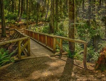
11 Apr The Grand Forest
BILT Admin The Grand Forest Click here for more information on our Stand for the Grand Forest campaign. Once upon a time, The Grand Forest was a dream without a reality. It was a dream that Island residents and the Bainbridge Island Metropolitan Park and Recreation District had before the Bainbridge Island Land Trust yet existed. From the Land Trust’s inception, the founders also saw an opportunity to preserve this vast, undeveloped landscape forever. Working with the State Department of Natural Resources, the Park District, and the community ensured that the Grand Forest properties would remain exactly as they are — undeveloped and available to the public for passive use such as trails, scenic vistas and natural areas. Why this property? The acquisition of these natural lands in the Island’s central core, made possible by voter-approved bonds, validated and catalyzed the vision of a major wildlife corridor — a continuous, publicly accessible section of conserved lands that would stretch across the island from east to west. From Meigs Park to Hilltop to the Heart of the Forest, the history and legacy of the Grand Forest extends beyond itself. It set the precedent and recalibrated expectations as to what is possible with conservation on the Island. The tremendous success of this vision is a testament to the power and influence of Islanders’ voices in keeping land natural and accessible. Acres Protected 233 acres Conservation Features Dense forest habitat Issei Creek Wetlands Multi-use trails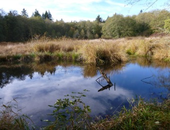
03 Apr Meigs Farm & Park
BILT Admin Meigs Park & Farm In 1992, the Land Trust helped to negotiate the acquisition of the 67-acre Meigs Park. Working with the landowner and our partners at the Bainbridge Island Metro Park and Recreation District, as well as the City of Bainbridge Island, this property was acquired through grants with the Washington Wildlife and Recreation Program and Kitsap County's Conservation Futures Fund. The land was eventually transferred to the Park District. An additional 20 acres adjacent to the park (Meigs Farm) were purchased by the City of Bainbridge Island. The Land Trust holds conservation easements on both Meigs Park and Farm. Why this property? Meigs Park and Farm not only offer great scenic beauty from Highway 305 and Koura Road, the property provides a rich, ecosystem including wetlands, forest, native grasslands, ponds, a stream, native plants, and wildlife habitat. This substantial, undeveloped property created a basis for additional conservation projects in the Island's central core including the Land Trust's Wildlife Corridor and Wildlife Corridor Expansion properties, the Hilltop connection in the Grand Forest, a number of private conservation easements, and the Forest to Sky trail to Battle Point Park. Acres Protected 87.28 acres Conservation Features Scenic & open space values Habitat for migratory birds Stream Wetlands Wildlife habitat